


MANILA — On Friday, a 6.9 magnitude earthquake struck, occurred at a depth of 10 km in the Philippines’ Mindanao region, according to the German Research Centre for Geosciences (GFZ). And no tsunami is expected, according to the Pacific Tsunami Warning Centre.
The quake struck at 4:14 p.m. (local time), according to Phivolcs (Philippine Institute of Volcanology and Seismology). Its epicenter was 05.37° North, 125.15° East – 030 kilometers south and 81 kilometers west of Sarangani, Davao Occidental. The offshore quake is expected to cause damage and aftershocks, according to a bulletin issued by the Philippines’ seismology agency.
It added that intensity 8 was felt in the southern Philippines provinces of Sarangani and South Cotabato. There were no casualties reported at the time. The seismology agency in the Philippines said the quake lasted several seconds and warned residents to be on the lookout for aftershocks and damage.
According to radio announcer Leny Aranego of General Santos, South Cotabato, the strong earthquake damaged walls and knocked some computers off desks. He also said that they saw how the walls cracked and computers fell was terrifying. Passengers at a General Santos City airport were evacuated to the tarmac, according to Michael Ricafort, who was about to board a flight to Manila when the quake struck.
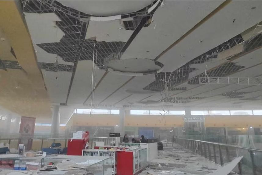
In a video shared in social media, people in there were panicking and running out the door. They were more concerned about a stampede occurring at the event due to the large number of people present. A photo shared on Facebook and confirmed by local authorities showed a collapsed ceiling inside a shopping mall in General Santos City, which was less than 100 kilometers from the epicenter. According to Adrian Imbong, an emergency medical services worker, about 30 students at a city high school were treated for breathing difficulties caused by the quake.
Captain Giecarrjune Villarin of the Sarangani municipality police department described the quake as the strongest of all. He and his co-workers fled their building on the island, which is about 30 kilometers southeast of the epicenter of the earthquake. He also added – “we saw people run out of a nearby gym where they had been playing basketball.” They did not have received any reports of damage or casualties as of now. Raquel Balaba, 58, was at a primary school in General Santos City with her grandchildren when they felt the ground shake. They were in an open field but the earthquake was so strong that the children got really scared and started crying, he told the news agency.

Source: The Straits Times
People have seen blocks of cement falling from a construction crane from the top of a building in Matina, Davao City. Many office buildings have collapsed due to the strongest earthquake ever experienced in the Philippines.
The Philippines is demographically prone to earthquakes. It is located along the Pacific Ring of Fire, which causes frequent seismic and volcanic activity. Because of the region’s major tectonic plate collisions, many earthquakes of lesser magnitude occur on a regular basis.
Mindanao is famous for strong earthquakes, where 1897 is noted as remarkable. It happened on September 20, 1897, at 19:06 UTC, and September 21, 1897, at 05:12 UTC. The two earthquakes’ estimated epicenters are located just off the south-western coast of Mindanao in the Philippines, south of Basilan Island. According to contemporary reports, all masonry buildings in Zamboanga and Basilan were left ruined. Because of the complex network of plates that surrounds the area, Manila and the rest of the Philippines are extremely vulnerable to large-scale earthquakes in general.


